Seismic activity in Corinth Gulf (Greece) in January 2010
Since 18th January 2010, the Corinth region is experiencing an important seismic activity with more than 130 earthquakes of magnitude spanning from 2.5 to 5.3 in less than 5 days.
The Corinth rift has been long identified as a site of major importance for earthquake studies in Europe, producing one of the highest seismic activities in the Euro-Mediterranean region: five earthquakes of magnitude greater than 5.8 in the last 35 years, 1 to 1.5 cm/year of north–south extension, frequent seismic swarms, and destructive historical earthquakes (Source: Corinth Rift Laboratory). Visit Corinth Rift Laboratory web page for more information.
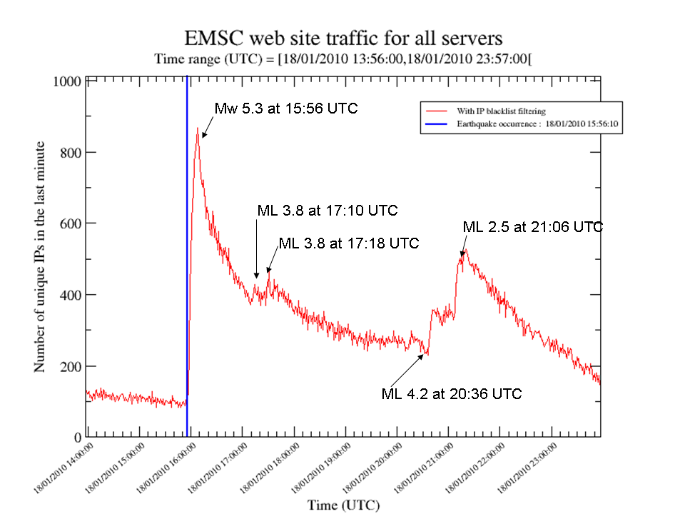
EMSC Web site Traffic variation
Over the past 5 years, the EMSC has developed mechanisms to use information captured from the EMSC web traffic to rapidly detect felt earthquakes and to map the extents of their effects. When an earthquake is felt, people turn to the internet to find out more. This in turn produces a surge in web traffic which is automatically detected (Figure 1.) Using Digital Element’s IP localization technology, we are able to identify the location from which the traffic originates. From this information, we automatically build “feltmaps” (Figure 2) – maps of where the earthquake has been felt. Significant absence of traffic from areas can indicate severe damage in those regions. Using these methods, we can detect the occurrence of an event in populated areas typically within 2-3 minutes, generally before we are able to publish the first automatic earthquake location using seismological data. These mechanisms respond to community input in the form of increased web traffic to rapidly detect events that are significant to the population and to map the extents of the effects. More information on feltmaps.
The felt map (Figure 2) allowed to detect that an earthquake has been widely in Greece in less than 5 minutes after the earthquake occurrence. This result is correlated by the observations derived from in-situ observations collected via the macroseismic questionnaires (Figures 3 and 4).
References:
- Citizen seismology page: http://www.citizenseismology.eu
- Video on EMSC Citizen Seismology: http://www.youtube.com/watch?v=wunAHj1KztQ
- Bossu R., Internet Users as Seismic Sensors for Improved Earthquake Response. EOS, Transactions, AGU, Vol. 89, No. 25, 225-226
- Web hits used to pinpoint earthquakes, New Scientist, 30/06/2008: Highlight on the earthquake detection technique used by the EMSC.
- European center tracks Web site hits after earthquakes, Government Computer News, 17/04/2009. Introducing the EMSC method of using IP addresses to locate earthquakes.
- ASeismic Shift in Earthquake Detection: Tracking Early Impact Through the Internet, 06/04/2009, by Digital Element (read the press release). Digital Element partnership for the detection of the IP location of EMSC web users.
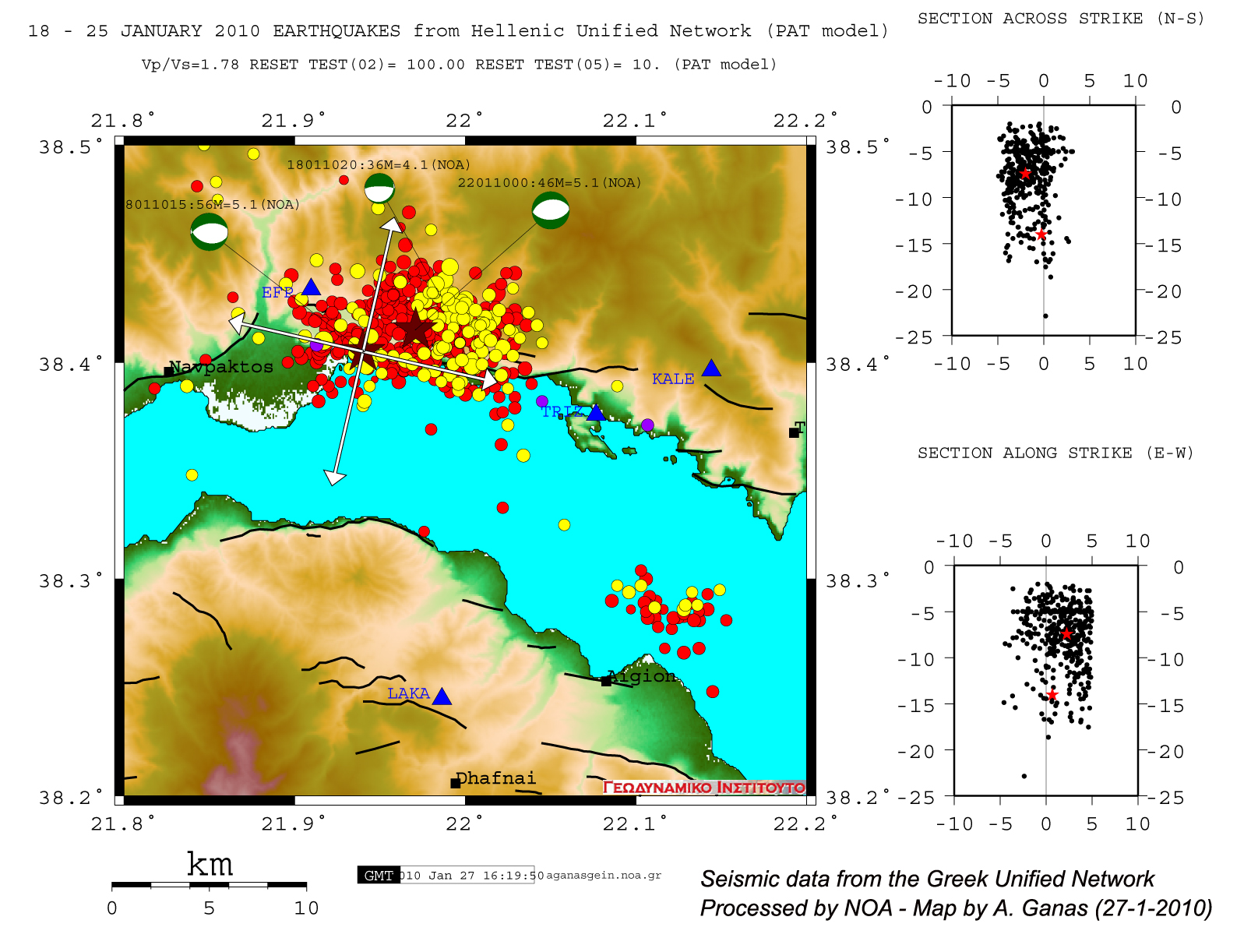
Seismicity map by the NOA
Seismicity map from 18 to 25 January 2010 with data from the Greek Unified Network (by A. Ganas; National Observatory of Athens)

Seismicity map by the EMSC
 Loading, please wait...
Earthquakes locations from 18/01/2010 until until 22/01/2010 13:00 UTC.
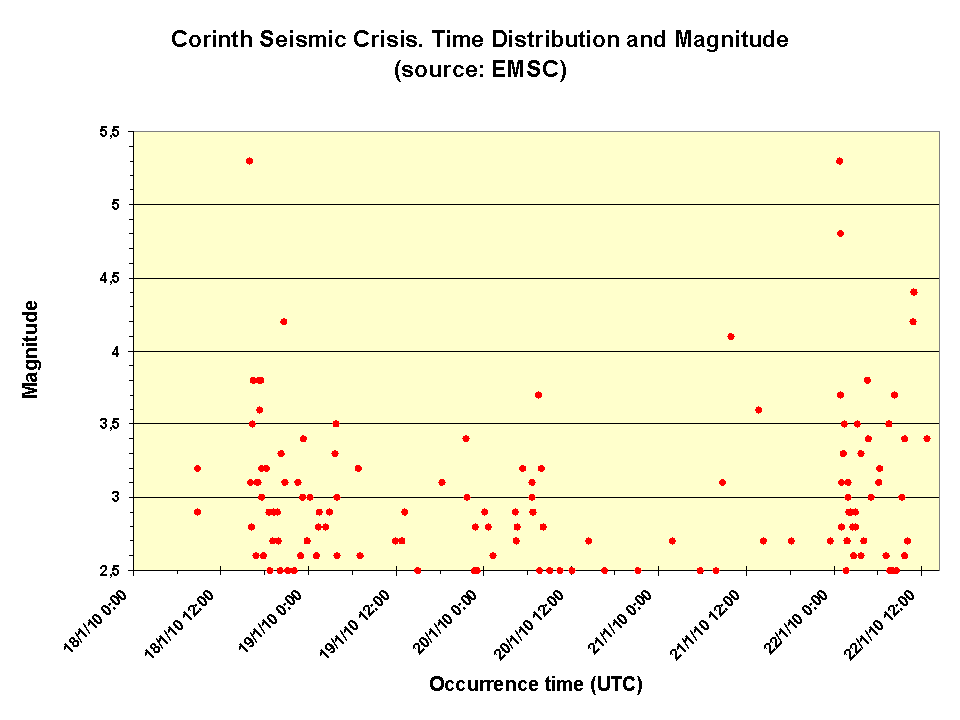
Earthquakes time distribution
Earthquakes temporal distribution in Corinth region from 18/01/2010 until 22/01/2010 15:00 UTC.

From 18/01/2010 until 22/01/2010 15:00 UTC, 131 earthquakes have been recorded by the EMSC from magnitude spanning from 2.5 to 5.3.
Regional Instrumental Seismicity
Source : ISC catalogue (1964-2004) and EMSC catalogue (2005-today)
Distribution by depth |
Distribution by magnitude |
 Mw 5.3 on 18/01/2010 at 15:56 UTC. Moment Tensors Solutions |


